


Drilling Down into Earth Observation
Sub-dividing the Segment

Of all the space SPACs, I think the ones in Earth Observation (EO) vertical are the most interesting. They’re operating varied numbers of satellites, they’ve got contracts with both government and commercial customers, and they’re pushing the envelope in terms of what value can be created from orbit.
The thing about these EO firms that I find most compelling, more in terms of advancing the state of industry than in a purely financial sense, is how they’re de-emphasizing the role of the space vehicle.
Much of the space industry relies on engaging the public with the idea of outer space to create excitement, through activities like rocket launch livestreams, and sending postcards to space.
But satellite companies don’t seem to feel the same way.
On a good day, nobody outside the firm really ought to think about how Spire’s constellation is doing. Customers should just put in a data order, and download it when they get a notification that it’s available.
EO operators should want to de-emphasize the spacecraft as a collector of data, and focus everybody’s attention on the value of the information gathered.
This is really where I believe the space industry needs to go. Focusing on the value-add for those of us on Earth is necessary for us as a society to normalize space activities, because it creates and reinforces links between the space sector and the rest of the economy.
The thing is that doing this in the EO vertical should take two very different forms — so much so that I’ve begun to wonder whether it’s actually one industry segment or two.
Type 1: Optical Data
The first type of EO data is optical data. At a technical level, this is basically sticking a camera on a satellite, pointing it towards the Earth, taking pictures, and downlinking or returning the images.
The key space SPACs doing this are Planet Labs and BlackSky; the most well-known incumbent is Maxar, which was bought out in spring 2023 by Advent.
Resolution from optical sensors can be highly variable, but at the end of the day, optical data basically looks similar to images taken from an airplane, similar to what we might find on Google Maps (in fact, a good deal of Google Maps imagery comes from satellites).
As an example of what optical data looks like today, Planet Labs took these images of the Disneyland Paris parking lot during summer 2020, and again in autumn 2023.

The GIF also highlights how easy it is for humans to pick out key features of the images. It’s possible to identify within the images water features, roads, buildings, and even cars.
Perhaps more importantly, the GIF calls attention to architectural changes between the images; the firm covered their parking lot in solar panels. With modern images, it even becomes possible to easily identify changes in the image texture and color — like how several building on the bottom right have been re-roofed.
Since humans can identify features of interest, it’s possible to train AI to identify them, which can turn interesting images into insights much more quickly and cheaply. As a result, this sort of data is relatively easily commercially actionable. This makes the value proposition relatively clear:
Optical data is helpful not just for human analysis, but for AI imagery analysis.
This is also apparent in the appearance of some optical data analytics companies.
But perhaps the most curious thing is that we’re not seeing more of these analytics startups, and I think it’s happening because companies have brought the analytics in-house. Since AI-based optical data analysis is essentially a solved ML problem, I think that what we’re seeing, or rather what we’re not, is the internalization of optical data analysis within firms.
The speed of data is so fast, and AI engineers are now so common, that it’s likely more efficient for a customer to build analysis tools internally than pay for them as a service.
The effect of this on a macro level is that this portion of the industry is unlikely to undergo vertical integration in the near- or long-term. I don’t expect to see a unicorn in the optical data analysis space.
Type 2: Everything Else
Taking a camera and looking “down” is only the tip of the iceberg in terms of EO data types! There are also space SPACs and startups collecting other types of data. A non-exhaustive list includes:
Multispectral/Hyperspectral data This consists of multiple images of the target taken at essentially the same time, in different parts of the electromagnetic spectrum. Some parts of the spectrum might be visible to the human eye, but they don’t have to be — infrared and ultraviolet bands in a multispectral dataset are quite common. Hyperspectral data is simply a special case of multispectral, where the EM bands used for imaging are continuous. Pixxel (a startup) is doing really interesting things in this space.

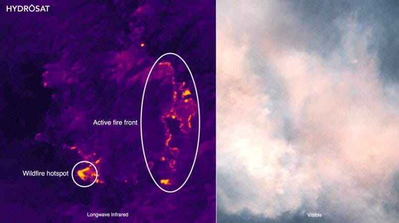
Infrared/Ultraviolet (IR/UV) Useful information about the Earth can be captured by satellites taking images in parts of the electromagnetic spectrum that are not visible to the human eye. UV applications to date focus mostly on environmental science. IR includes both near-infrared signatures, as well as thermal data. Hydrosat (a startup) is capturing some really interesting IR data, with applications for both the climate and agricultural fields.

Synthetic Aperture Radar (SAR) data If you know your satellite path and the ground stays still, you can essentially take a picture with radar. The particularly interesting thing about this is that it is unaffected by weather conditions like cloud cover, rain, and night time. Umbra (a startup) is a leader in this type of imaging.

Passive RF Radio transmissions, even those sent using directional transmitters, create noise. With a constellation of satellites, it’s possible to triangulate the location of the transmitters with a relatively high degree of precision, potentially identify the type of transmitter, and even collect transmitted data. Spire (a SPAC) and HawkEye360 (a startup) are leaders in this space; the image below show’s HawkEye360’s data product.

Gas emissions It’s possible to detect gas emissions, like methane and other environmentally unfriendly compounds, on Earth from orbit. GHGSat operates a constellation that’s taking a really cool approach to identifying greenhouse gas emissions and their sources.


It used to require a significant chunk of a superpower’s military space budget to collect this type of data, if the engineering capability to collect it from space even existed at all.
Because of the technical challenges and the institutions that collected these types of EO data, these types of information especially SAR and passive RF, were highly classified (data collected by some government agencies still is).
Based on the newness of the data, I am unconvinced that commercial users as a group really understand how to use the data efficiently (I’m sure some individual users already have). As a result, I think there’s tons of opportunities for application subject matter experts who understand the data to make a killing.
The consequence of this is that I see a much stronger case for vertical integration of analytics services and tools into EO data collection companies.
Insightful!